Military surveillance data: Shared intelligence
The military has a vast array of scientifically valuable data — some more accessible than you think.
No one monitors our planet more closely than the military. Thirty-six thousand kilometres above Earth, US Air Force satellites watch for the heat plume of a ballistic missile. An array of other surveillance satellites patrol lower altitudes. Some can see a rifle from space; others penetrate cloud cover with radar, seeking military hardware or installations. Still closer in, aircraft and drones fly over conflict zones collecting intelligence, and seismometers listen for shudders from an underground nuclear test. Even the deepest oceans are prowled by military submarines, watching their foreign adversaries.
Through most of their history, the data collected by this vast blanket of military sensors have been highly classified. But on occasions when scientists are lucky enough to see the data, their view is considerably different from that of the generals. Satellites designed to track missiles can also spot the flaming trails of meteors; aerial photographs of Iraq have allowed archaeologists to trace ancient canals. Even the military's most banal weather satellites collect data on ocean precipitation that are valuable for understanding Earth's energy cycles.
After the cold war, some of these data did start trickling out to scientists, mainly in the United States, which has vast military resources and a vibrant scientific community. The flow ebbed after 2000 — but there are hints that it is resuming, and that more fruitful data collaborations are to come. A group of security-cleared scientists called MEDEA has recently rekindled ties with the US intelligence community to discuss the use of military environmental data for the study of climate change. And an agreement set to be finalized in October between NASA and the US Air Force will give astronomers unprecedented access to data on meteors entering the atmosphere. Some details of those data must be obfuscated to preserve state secrets, but researchers say that the trove nonetheless has enormous scientific potential. "I think it's become more useful now than it ever has been before," says John Orcutt, an oceanographer at the University of California, San Diego, and a member of MEDEA.
In the United States, the start of the Manhattan Project in 1942 set the tone for collaboration between the modern military and civilian scientists. The greatest physicists of the era, conscripted to build the atomic bomb, spent years working closely with the US Army. The Pentagon has used outside scientists to help shape its capabilities ever since. It maintains a handful of quasi-academic labs near university campuses, and a truculent panel of independent scientists — known as the JASONs — advises it on technical topics such as submarine detection and nuclear weapons (see page 397).
At the same time, opportunistic collaborations have sprung up between civilian scientists and the defence establishment. With the advent of nuclear submarine warfare in the 1950s, the US Navy devoted enormous resources to mapping and understanding the sea floor — including mid-ocean ridges, where Navy mapping yielded clues to the theory of plate tectonics, according to Raymond Jeanloz, an Earth scientist at the University of California, Berkeley, and a long-time member of the JASONs. Seismic networks used to monitor nuclear tests have also mapped earthquakes. Jeffrey Richelson, a historian at the National Security Archive in Washington DC, says that since the 1970s, the US defence department has occasionally shared satellite imagery with civilian agencies in response to natural disasters such as flooding and forest fires.
But the military's most sensitive data remained off-limits to academics. In 1967, for example, early-warning radar in Alaska spotted pulsars — rotating stars that emit a pulsing radio signal — months before any civilian astronomers did. The staff sergeant who made the observations kept quiet about his discovery for 40 years, until the sightings were declassified in 20071.
After the end of the cold war, restrictions began to loosen. In the mid-1990s, astronomers struck up an ad hoc arrangement with Air Force Space Command in which they could ask for data on specific meteors that had been collected by missile-warning satellites. At around the same time, Al Gore, then a Democratic senator from Tennessee, began to ask what the intelligence community could offer climate scientists. Gore was interested in environmental issues and had also served on intelligence and military committees in Congress. He wrote to Robert Gates, then the director of the Central Intelligence Agency, prompting Gates to invite a group of scientists to gain security clearance and take a look at what the military had to offer. After Gore took office as Bill Clinton's vice-president in 1993, the group solidified under the name MEDEA — Measurements of Earth Data for Environmental Analysis.
"With the proper justification, I could ask for almost anything," says William Schlesinger, a MEDEA member and president of the Cary Institute of Ecosystem Studies in Millbrook, New York. Schlesinger used reconnaissance imagery going back to the Second World War to search for climate change's influence on desertification of the Sahara (he didn't find any)2.
Trade secrets
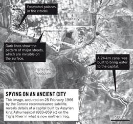
MEDEA did succeed in getting intelligence satellites to systematically photograph locations of environmental interest in the Arctic, Antarctic and the continental United States. In 1995, the group also successfully lobbied for the release of images from early photo-reconnaissance satellites Corona, Argon and Lanyard, which took more than 860,000 photographs of Earth between 1960 and 1972, recorded on rolls of film. Since then, an entire cottage industry has sprung up involving archaeologists who search for roads and other ancient features in the photos, many of which show tracts of land that have since been consumed by urban sprawl. Jason Ur, an archaeologist at Harvard University in Cambridge, Massachusetts, for example, has used them to map massive canals dug by ancient Assyrian kings3 (see 'Spying on an ancient city').
 Click for full map
In the late 1990s, work by Gore and MEDEA led the United States and Russia to declassify Arctic-sea-ice data recorded between the 1970s and 1990s by satellites, submarines and other sources. Scientists have since been able to use those data to reconstruct the gradual thinning of Arctic ice in the decades before civilian monitoring began. "Without the early classified data, people wouldn't have a clue," says Ralph Cicerone, the president of the US National Academy of Sciences.
Then, around 2000, MEDEA abruptly halted its work and, in 2009, the informal meteor data from the Air Force stopped flowing too. No one really knows why. But such twists and turns are the price of working with the intelligence community. As Schlesinger puts it, researchers aren't privy to the "darkened world where a bunch of people make a decision".
Sharing will never be a priority for those charged with defending the United States, says Steven Aftergood, who heads the Project on Government Secrecy at the Federation of American Scientists in Washington DC and has spent decades tracking the US intelligence agencies. Even if information is unclassified, agencies may not want to dole it out freely — or devote resources to converting it into formats that scientists can use. "No organization spontaneously discloses and shares its information; that's just a bureaucratic law of physics," Aftergood says. Political pressure, such as that applied by Gore, is key to persuading intelligence agencies to share data, he says.
“With the proper justification, i could ask for almost anything.”
These days, new collaborations are emerging. In 2008, congressional committees concerned about climate change quietly reconvened MEDEA to examine whether military- and intelligence-community assets could supply environmental data. The answer was yes, according to Cicerone, who has served as informal chair of MEDEA since 2008. Although intelligence satellites aren't as useful as custom-built instruments, the panel concluded that they could fill some gaps in climate data gathered by civilian satellites, particularly given recent budget shortfalls and launch failures such as the loss of the NASA Orbiting Carbon Observatory in February 20094.
Also in 2009, MEDEA persuaded intelligence officials to publicly share images of areas of environmental interest that had, by that time, been photographed regularly for more than a decade. The images are now archived as the Global Fiducials Library, available through the US Geological Survey (USGS). Orcutt says they are "relatively priceless at this point" because they are gathered roughly once every few weeks — more frequently and continuously than those from civilian research satellites.
Lindley Johnson, who oversees NASA's Near-Earth Object Observation programme, believes that the space policy unveiled in 2010 by US President Barack Obama, which explicitly endorses data sharing, may have smoothed his efforts to secure data from the US Air Force. Johnson says the new arrangement, which will give astronomers access to data from missile-warning satellites on all meteors — not just the ones researchers knew about already — will allow scientists to gain a better understanding of the range of near-Earth objects in orbit.
ADVERTISEMENT

How much science will emerge from these burgeoning relationships remains to be seen. So far, the newly available image libraries of the Arctic and Antarctic have seen only modest use from scientists. "One of our biggest challenges is to educate the science community about the existence of our programme," says Bruce Molnia, executive director of the Civil Applications Committee at the USGS in Reston, Virginia, which oversees civilian use of classified image data. And the members of MEDEA, who have access to the full array of classified data, are, for now at least, using it to address policy questions raised by government agencies — such as what national security risks are posed by climate change — rather than conducting fundamental research of their own choosing.
Yet Cicerone is hopeful that even more of the intelligence data being collected can eventually be shared. It is now feasible to save almost everything that the military's eyes and ears are recording about Earth. "As scientists, we don't want observations to be thrown away," he says. "With the Earth, as time passes, you just get one shot at it."
See Editorial page 369
Geoff Brumfiel is a senior reporter for Nature in London .